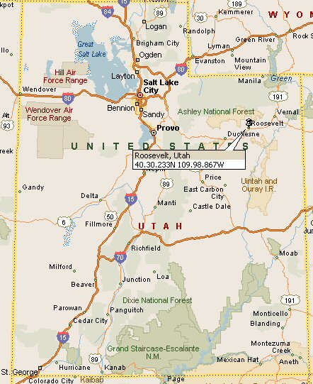
Roosevelt, Duchesne County, Utah (State Map)
Area Map
Go to
County Map
   
Stree Map
   
Google
 
Web OnlineUtah.com
Comments & Questions to OnlineUtah.com

Home | Area Codes | Cities | Climate | Credits | Counties | Dining | Dinosaurs | Disclaimer | Education | Entertainment | Government | Health | History | Hot Springs | Industry | Lakes | Lodging | Maps | Media | Mountains | Museums | Parks | People | Photo Gallery | Quick Facts | Quizzes | Recreation & Sports | Religion | Rivers | Sites | Travel | Weather

Zoom In Nephi, Utah St. George, Utah Aneth, Utah Kanab, Utah Hurricane, Utah Mexican Hat, Utah Montezuma Creek, Utah Blanding, Utah Cedar City, Utah Panguitch, Utah Parowan, Utah Junction, Utah Loa, Utah Monticello, Utah Moab, Utah Beaver, Utah Milford, Utah Richfield, Utah Gandy, Utah Fillmore, Utah Delta, Utah Manila, Utah Vernal, Utah Roosevelt, Utah Duchesne, Utah Manti, Uth Castle Dale, Utah East Carbon City, Utah Price, Utah Provo, Utah Sandy, Utah Bennion, Utah Salt Lake City, Utah Layton, Utah Ogden, Utah Brigham City, Utah Randolph, Utah Logan, Utah Alta, Utah Alta, Utah Logan, Utah Randolph, Utah Brigham City, Utah Ogden, Utah Manila, Utah Layton, Utah Bennion, Utah Sandy, Utah Ashley National Park, Utah Vernal, Utah Wendover, Utah Roosevelt, Utah Roosevelt, Utah Gandy, Utah Duchesne, Utah Provo, Utah Delta, Utah Utah Lake, Utah Price, Utah East Carbon City, Utah Castle Dale, Utah Manti, Utah Uintah and Ouray Indian Reservation, Utah Fillmore, Utah Richfield, Utah Milford, Utah Loa, Utah Junction, Utah Beaver, Utah Parowan, Utah Panguitch, Utah Dixie National Forest, Utah Hurricane, Utah St. George, Utah Cedar City, Utah Kanab, Utah Grand Staircase-Escalante, Utah Mexican Hat, Utah Aneth, Utah Montezuma Creek, Utah Blanding, Utah Monticello, Utah Moab, Utah Lake Powell, Utah Bear Lake, Utah Great Salt Lake, Utah Wendover Air Force Range, Utah Salt Lake City, Utah Hill Air Force Range, Utah